New files in: 1 day, 3 days, 7 days, 30 days
| Most downloaded for: all time,
year,
half a year,
month,
two weeks,
three days
Most popular by rating | Submit a file
Most popular by rating | Submit a file
| Folder: |
Bethel Sectional Chart
| Rating: 5!
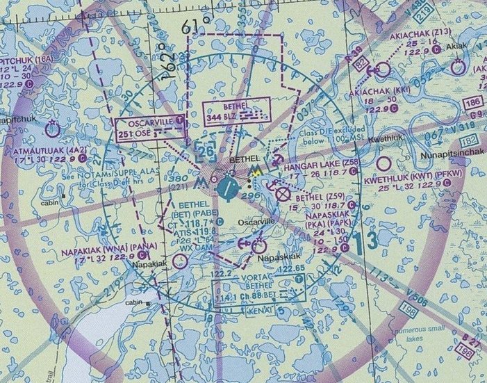
Map in JPEG format 7352x5470. Covers Bethel area and St. Lawrence Island. Valid until 29 July 2010.
→ Size:
11 MB
→ Date:
16 years ago (09.11.2009 02:28)
→ Author:
FAA
→ Approved by moderator:
Lenya69
→ License:
Freeware - Free version, Unlimited Distribution
→ Downloaded:
203 time(s)
Nome sectional chart
| Rating: 5!
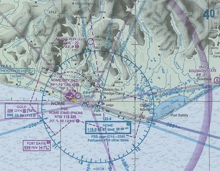
Map in JPEG format 7360x5457. Covers part of Alaska's west coast, and also small part of Chukotskiy peninsula. Valid until 1 Jul 2010
→ Size:
11 MB
→ Date:
16 years ago (09.11.2009 02:22)
→ Author:
FAA
→ Approved by moderator:
Lenya69
→ License:
Freeware - Free version, Unlimited Distribution
→ Downloaded:
275 time(s)
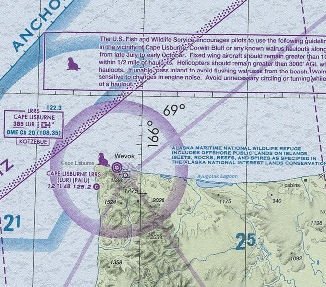
Map format in JPEG 7338x5457. Covers North-West Alaska coastline from Point Hope to Barrow. Effective until 26 August 2010.
→ Size:
10 MB
→ Date:
16 years ago (03.11.2009 12:14)
→ Author:
FAA
→ Approved by moderator:
lkn
→ License:
Freeware - Free version, Unlimited Distribution
→ Downloaded:
210 time(s)
Miami Sectional Chart
| Rating: 5!
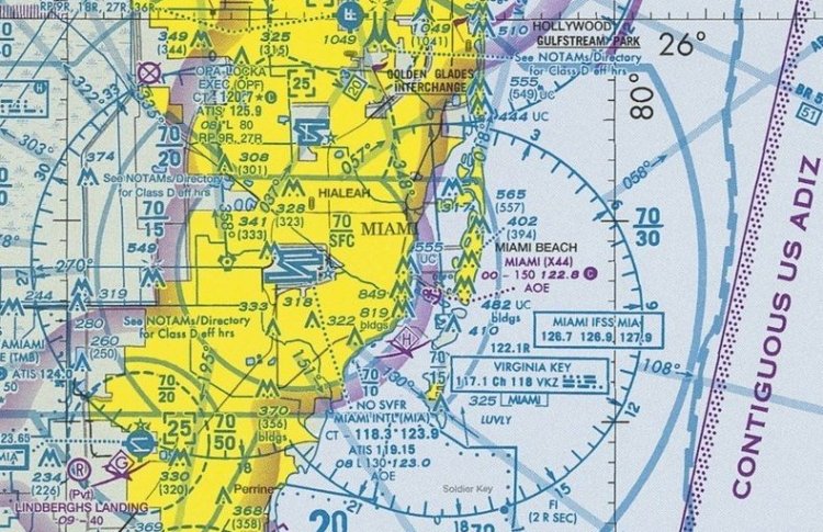
Map format in JPEG 7656x5448. Covers southern Florida from Tampa area to key west, and also parts of Bahamas. Valid to 11 Feb 2010.
→ Size:
11 MB
→ Date:
16 years ago (03.11.2009 12:14)
→ Author:
FAA
→ Approved by moderator:
lkn
→ License:
Freeware - Free version, Unlimited Distribution
→ Downloaded:
277 time(s)
Hawaii Sectional chart
| Rating: 5!

Hawaii Sectional chart in JPEG format 6817x5694 pixels. Covers area between islands of Hawaii and Niihau. Unfortunately, legend is not included, but it can easily be found on other charts uploаded here.
→ Size:
6 MB
→ Date:
16 years ago (30.10.2009 08:52)
→ Author:
FAA
→ Approved by moderator:
ReDut
→ License:
Freeware - Free version, Unlimited Distribution
→ Downloaded:
507 time(s)
RNA P-3 07maya09
| Rating: 5!

RNA CAICA. Sheet P-3. 07maya09. Irrelevant to the actual Navigation - removed from the BAI in sen09. Neskleena (8 pieces). 150dpi.
→ Size:
6 MB
→ Date:
16 years ago (26.10.2009 12:54)
→ Author:
ЦАИ ГА. Сканирование — Экзот
→ Approved by moderator:
SLAVJAN
→ License:
Freeware - Free version, Unlimited Distribution
→ Downloaded:
770 time(s)
RNA CAICA R-2 07maya09
| Rating: 5!

RNA CAICA P-2. Armenia, Azerbaijan, Belarus, Georgia, Russia, Ukraine. Neskleenaya. 150dpi.
→ Size:
15 MB
→ Date:
16 years ago (26.10.2009 10:01)
→ Author:
ЦАИ ГА. Сканирование — Экзот
→ Approved by moderator:
seric76
→ License:
Freeware - Free version, Unlimited Distribution
→ Downloaded:
1457 time(s)
RNA CAICA R-Mil 02iyul09
| Rating: 5!
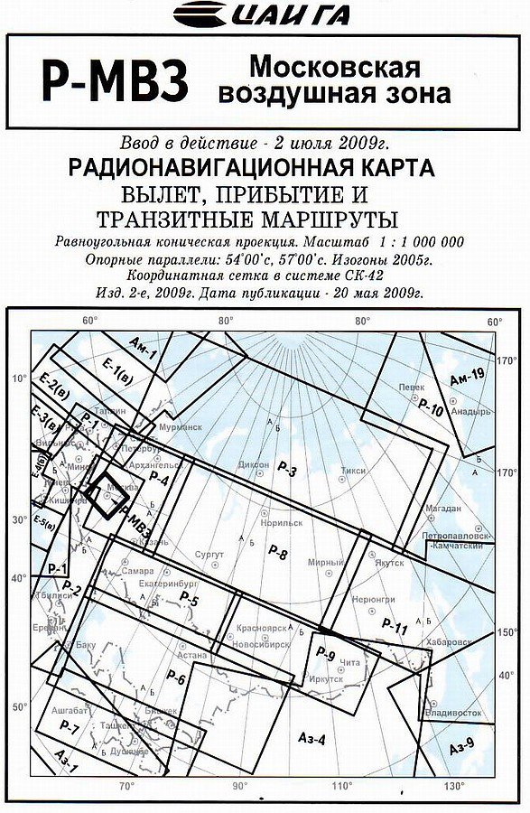
RNA CAICA R-Mil from 02iyul09. Removed from the BAI in sen09. Resolution 150dpi. Neskleenaya.
→ Size:
4 MB
→ Date:
16 years ago (24.10.2009 16:07)
→ Author:
ЦАИ ГА. Сканирование — Экзот
→ Approved by moderator:
omega
→ License:
Freeware - Free version, Unlimited Distribution
→ Downloaded:
1060 time(s)
Juneau Sectional Aeronautical Chart
| Rating: 5!
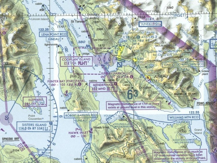
Both sides of the sheet in hi-res pasted together complete with legend and notes, size 7315x5342 pixels. Effective through 04/08/10. Covers south Alaska and western British Columbia. That is a big part of Tongass Fjords scenery in simulator.
→ Size:
13 MB
→ Date:
16 years ago (13.10.2009 20:32)
→ Author:
NACO
→ Approved by moderator:
Lenya69
→ License:
Freeware - Free version, Unlimited Distribution
→ Downloaded:
370 time(s)
Ketchikan Sectional Aeronautical Chart
| Rating: 5!
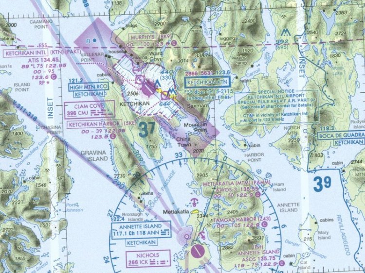
The chart covers the southernmost end of Alaska and Canadian Graham Island. Both sides of the sheet in hi-res pasted together complete with legend and notes. Size 7339x5345 pixels.
→ Size:
8 MB
→ Date:
16 years ago (13.10.2009 02:54)
→ Author:
NACO
→ Approved by moderator:
Lenya69
→ License:
Freeware - Free version, Unlimited Distribution
→ Downloaded:
443 time(s)
Seattle VFR Terminal Area Chart
| Rating: 5!


Both sides of the sheet in hi-res pasted together complete with legend and notes, size 7944х5498 pixels. Effective through 12/17/09. Covers the whole Washington state and the northern part of Oregon with large cities of Seattle, Portland and Vancouver. Invalueable for the owners of the sceneries by Georender and FSAddon and also FlightZone 02: Portland.
→ Size:
18 MB
→ Date:
16 years ago (11.10.2009 03:55)
→ Author:
NACO
→ Approved by moderator:
Lenya69
→ License:
Freeware - Free version, Unlimited Distribution
→ Downloaded:
294 time(s)
Boston VFR Terminal Area Chart
| Rating: 5!

Complete sheet in hi-res with legend and notes, size 4659x3953 pixels. Valid through 11/19/09. May be of particular interest to the owners of Martha's Wineyard and FlightZone 01: Rhode Island sceneries.
→ Size:
5 MB
→ Date:
16 years ago (10.10.2009 03:12)
→ Author:
NACO
→ Approved by moderator:
Lenya69
→ License:
Freeware - Free version, Unlimited Distribution
→ Downloaded:
227 time(s)

Detailed topographical map for the PVP in the area of Naryan Mar
→ Size:
3 MB
→ Date:
16 years ago (06.09.2009 20:26)
→ Author:
неизвестно
→ Approved by moderator:
smart32
→ License:
Freeware - Free version, Unlimited Distribution
→ Downloaded:
289 time(s)
RNA Ukraine
| Rating: 5!

Radar map of Ukraine
→ Size:
14 MB
→ Date:
17 years ago (14.04.2009 13:55)
→ Author:
Укравиапоиск
→ Approved by moderator:
AirArt
→ License:
Freeware - Free version, Unlimited Distribution
→ Downloaded:
1675 time(s)