New files in: 1 day, 3 days, 7 days, 30 days
| Most downloaded for: all time,
year,
half a year,
month,
two weeks,
three days
Most popular by rating | Submit a file
Most popular by rating | Submit a file
| Folder: |

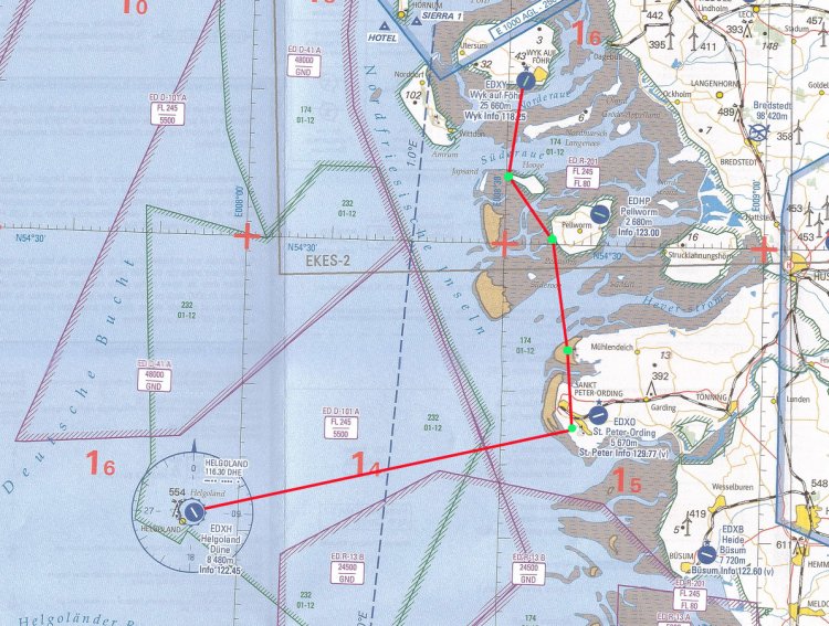
Visual map of flights in areas of major ports of Germany. For better orientation performed on a scale of 1:250 000 or 1:300 000 - in contrast to the usual flight 1:500 000 maps. Relevance of early 2010. Example maps in the archive.
→ Size:
21 MB
→ Date:
15 years ago (26.09.2010 13:23)
→ Author:
Издатель - DFS.
→ Approved by moderator:
seric76
→ License:
Freeware - Free version, Unlimited Distribution
→ Downloaded:
596 time(s)
VFR Chart ED-1
| Rating: 5!
CJ-27 World Aeronautical Chart
| Rating: 5!
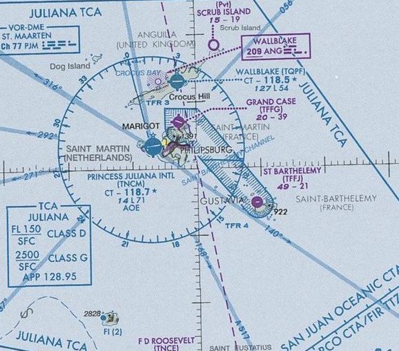
Map in JPEG format 7965x5488. Covers islands such as Hispaniola, Caicos, Saint Martin, Guadeloupe, and others in between. Valid until 5 April 2012
→ Size:
8 MB
→ Date:
15 years ago (14.07.2010 06:42)
→ Author:
FAA
→ Approved by moderator:
Lenya69
→ License:
Freeware - Free version, Unlimited Distribution
→ Downloaded:
514 time(s)
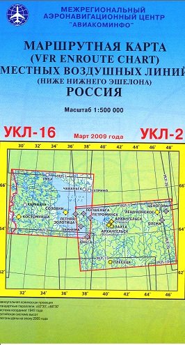
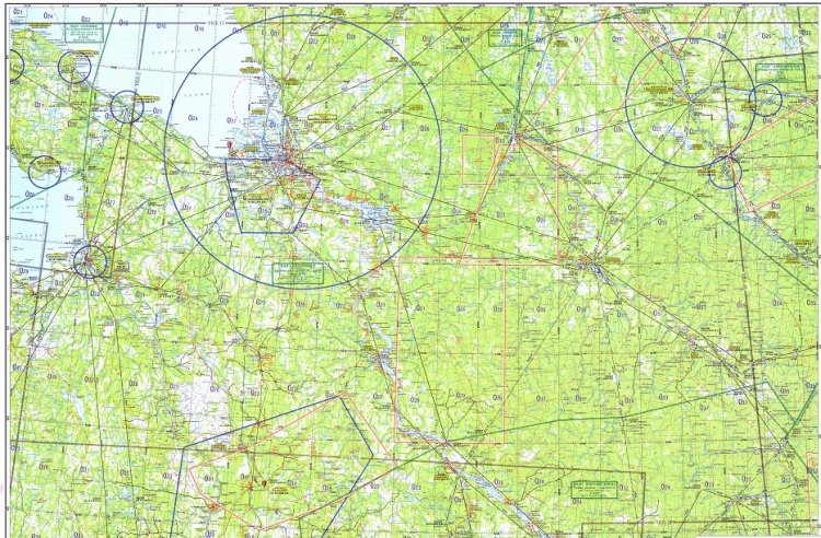
UKL-2 Archangel, Plesetsk
| Rating: 5!
UKL-8 Volgograd
| Rating: 5!
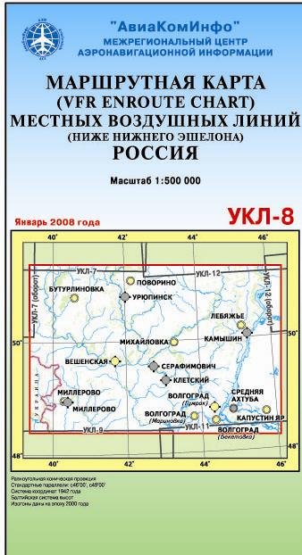
Route map MVL (below the lower tier) for VFR flights, UKL-8: Volgograd, Kamyshin, Lebyazhye. ---------------------------- ---------------------------------------- route map scale of 1:500 000 is designed to prepare and mission of local airlines and outside (below the lower echelon). The map was published the following aeronautical information: local airlines, with their indexes, magnetic travel angles, distances between two points and directions of traffic flow; border TIR (VMDP) with Provide data management, airport ground network, heliports and helipads, radio navigation points, indicating their names, signs, frequencies and geographical coordinates; restricted areas, restricted operations, hazardous areas and reserves, including its vertical boundaries; artificial obstacles.
→ Size:
12 MB
→ Date:
16 years ago (14.06.2010 01:31)
→ Author:
МАНЦ АвиаКомИнфо
→ Approved by moderator:
Lenya69
→ License:
Freeware - Free version, Unlimited Distribution
→ Downloaded:
887 time(s)
The route map MVL UKL-16. March 2009
→ Size:
71 MB
→ Date:
16 years ago (14.06.2010 01:09)
→ Author:
МАНЦ АВИАКОМИНФО
→ Approved by moderator:
Lenya69
→ License:
Freeware - Free version, Unlimited Distribution
→ Downloaded:
618 time(s)
UKL-3 Petrozavodsk
| Rating: 5!
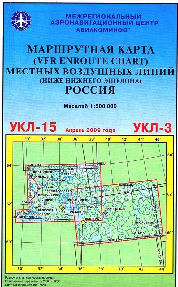
The route map MVL UKL-3.
→ Size:
67 MB
→ Date:
16 years ago (14.06.2010 00:46)
→ Author:
МАНЦ АВИАКОМИНФО
→ Approved by moderator:
Lenya69
→ License:
Freeware - Free version, Unlimited Distribution
→ Downloaded:
662 time(s)
UKL-1 Severomorsk, Murmansk, Kirovsk
| Rating: 5!
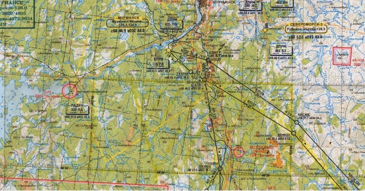
The route map MVL UKL-1.
→ Size:
12 MB
→ Date:
16 years ago (14.06.2010 00:09)
→ Author:
Неизвестен
→ Approved by moderator:
Lenya69
→ License:
Freeware - Free version, Unlimited Distribution
→ Downloaded:
724 time(s)
CJ-26 World Aeronautical Chart
| Rating: 5!
Map in JPEG format 7931x5452. Covers Cuba, Jamaica, and parts of Haiti and the Bahamas. Valid until 9 February 2012
→ Size:
9 MB
→ Date:
16 years ago (26.04.2010 07:06)
→ Author:
FAA
→ Approved by moderator:
seric76
→ License:
Freeware - Free version, Unlimited Distribution
→ Downloaded:
481 time(s)
Detroit Helicopter Chart
| Rating: 4!
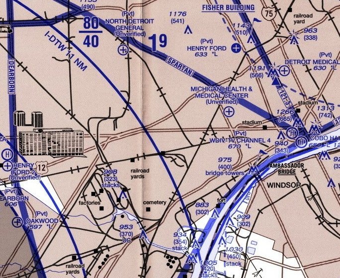
Map in JPEG format 6031x4041. Covers Detroit City and suburbs. 1st Edition: Aug 4 2005.
→ Size:
6 MB
→ Date:
16 years ago (20.04.2010 14:01)
→ Author:
FAA
→ Approved by moderator:
Aleks_Balagur
→ License:
Freeware - Free version, Unlimited Distribution
→ Downloaded:
148 time(s)
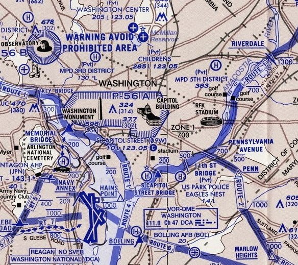
Map in JPEG format 5970x2652. Covers Washington DC/Northern Virginia and surrounding suburbs. Edition: 30 Jul 2009
→ Size:
5 MB
→ Date:
16 years ago (18.04.2010 11:18)
→ Author:
FAA
→ Approved by moderator:
UDVA
→ License:
Freeware - Free version, Unlimited Distribution
→ Downloaded:
185 time(s)
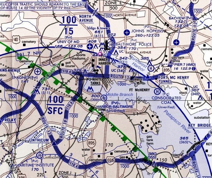
Map in JPEG format 5286x2645. Covers Baltimore city and suburbs. An insert chart also covers Washington downtown.
→ Size:
4 MB
→ Date:
16 years ago (18.04.2010 11:18)
→ Author:
FAA
→ Approved by moderator:
UDVA
→ License:
Freeware - Free version, Unlimited Distribution
→ Downloaded:
135 time(s)
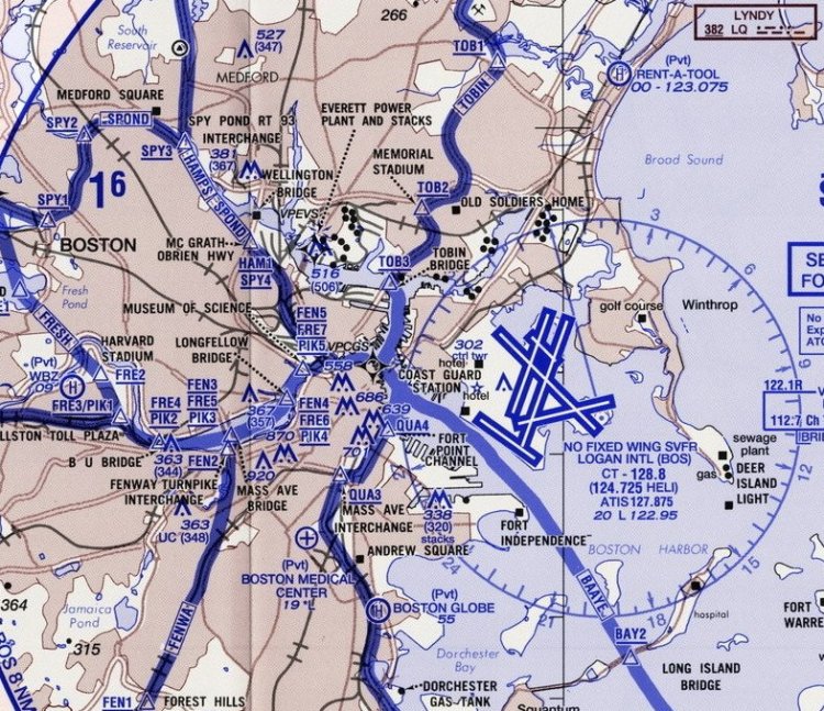
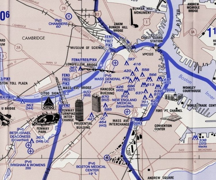
Map in JPEG format 4677x3877. Covers City of Boston and adjoining suburbs. Edition: 20 Dec 2007
→ Size:
4 MB
→ Date:
16 years ago (03.04.2010 10:51)
→ Author:
FAA
→ Approved by moderator:
UDVA
→ License:
Freeware - Free version, Unlimited Distribution
→ Downloaded:
136 time(s)
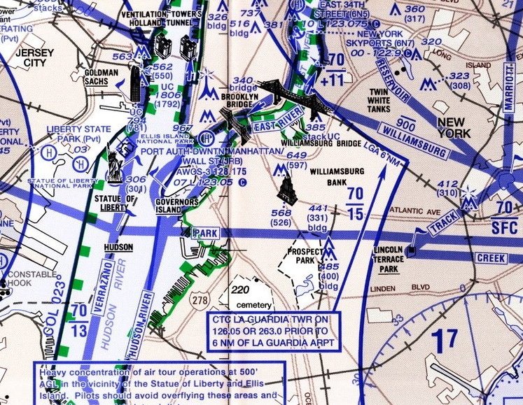
Map in JPEG format 6010x4013. Covers New York City and adjacent suburbs. Edition: 19 Nov 2009
→ Size:
6 MB
→ Date:
16 years ago (03.04.2010 10:22)
→ Author:
FAA
→ Approved by moderator:
UDVA
→ License:
Freeware - Free version, Unlimited Distribution
→ Downloaded:
208 time(s)