FlightSim + FliteDeck Просмотр ZIP-архива
FlightSim+FliteDeck/Протоколы NMEA.txt
Протоколы NMEA

RMC - поставляет данные о курсе и скорости относительно земли.
Как правило, в потоках пишется так GPRMC,125504.049,A,5542.2389,N,03741.6063,E,0.06,25.82,200906,,*3B
RMA - поставляет данные о курсе и скорости относительно земли
VTG - поставляет данные о курсе и скорости относительно земли (обычно используется с GLL)
GGA - поставляет данные о высоте
GLL - поставляет данные о высоте, но GGA работает лучше
GSA - поставляет мало полезную информацию от спутников, используется вместе с GGA.
GSV - аналогично, ничего полезного из GPS, но для некоторых программ поставляет
фиксированные спутниковые данные.
AV400 – поставляет данные от некоторых бортовых GPS устройств.

Собственные строки фирмы Garmin
PGRME — оценка ошибки измерений
PGRMM — картографические данные
PGRMZ — высота
PSLIB — контроль приёма маяков


Все протоколы
$GPxxx

$GPAAM - Waypoint Arrival Alarm
$GPALM - GPS Almanac Data
$GPAPA - Autopilot format "A"
$GPAPB - Autopilot format "B"
$GPASD - Autopilot System Data
$GPBEC - Bearing & Distance to Waypoint, Dead Reckoning
$GPBOD - Bearing, Origin to Destination
$GPBWC - Bearing & Distance to Waypoint, Great Circle
$GPBWR - Bearing & Distance to Waypoint, Rhumb Line
$GPBWW - Bearing, Waypoint to Waypoint
$GPDBT - Depth Below Transducer
$GPDCN - Decca Position
$GPDPT - Depth
$GPFSI - Frequency Set Information
$GPGGA - Global Positioning System Fix Data
$GPGLC - Geographic Position, Loran-C
$GPGLL - Geographic Position, Latitude/Longitude
$GPGRS - GPS Range Residuals
$GPGSA - GPS DOP and Active Satellites
$GPGST - GPS Pseudorange Noise Statistics
$GPGSV - GPS Satellites in View
$GPGXA - TRANSIT Position
$GPHDG - Heading, Deviation & Variation
$GPHDT - Heading, True
$GPHSC - Heading Steering Command
$GPLCD - Loran-C Signal Data
$GPMSK - Control for a Beacon Receiver
$GPMSS - Beacon Receiver Status
$GPMTA - Air Temperature (to be phased out)
$GPMTW - Water Temperature
$GPMWD - Wind Direction
$GPMWV - Wind Speed and Angle
$GPOLN - Omega Lane Numbers
$GPOSD - Own Ship Data
$GPR00 - Waypoint active route (not standard)
$GPRMA - Recommended Minimum Specific Loran-C Data
$GPRMB - Recommended Minimum Navigation Information
$GPRMC - Recommended Minimum Specific GPS/TRANSIT Data
$GPROT - Rate of Turn
$GPRPM - Revolutions
$GPRSA - Rudder Sensor Angle
$GPRSD - RADAR System Data
$GPRTE - Routes
$GPSFI - Scanning Frequency Information
$GPSTN - Multiple Data ID
$GPTRF - TRANSIT Fix Data
$GPTTM - Tracked Target Message
$GPVBW - Dual Ground/Water Speed
$GPVDR - Set and Drift
$GPVHW - Water Speed and Heading
$GPVLW - Distance Traveled through the Water
$GPVPW - Speed, Measured Parallel to Wind
$GPVTG - Track Made Good and Ground Speed
$GPWCV - Waypoint Closure Velocity
$GPWNC - Distance, Waypoint to Waypoint
$GPWPL - Waypoint Location
$GPXDR - Transducer Measurements
$GPXTE - Cross-Track Error, Measured
$GPXTR - Cross-Track Error, Dead Reckoning
$GPZDA - UTC Date / Time and Local Time Zone Offset
$GPZFO - UTC & Time from Origin Waypoint
$GPZTG - UTC & Time to Destination Waypoint
39980-FlightSimFliteDeck.zip
| Имя файла | Дата | Размер |
|---|---|---|
| FlightSim+FliteDeck/ | 13.08.2011 00:20 | |
| FlightSim+FliteDeck/GPSout/ | 12.08.2011 23:53 | |
| FlightSim+FliteDeck/GPSout/GPSout.dll | 15.11.2005 19:03 | 18 KB |
| FlightSim+FliteDeck/GPSout/GPSout.ini | 08.08.2011 01:58 | 4 KB |
| FlightSim+FliteDeck/VSPE (Эмулятор COM-портов)/ | 12.08.2011 23:53 | |
| FlightSim+FliteDeck/VSPE (Эмулятор COM-портов)/SetupVSPE.msi | 27.06.2010 02:26 | 3 MB |
| FlightSim+FliteDeck/VSPE (Эмулятор COM-портов)/version.txt | 27.06.2010 02:26 | 251 B |
| FlightSim+FliteDeck/VSPE (Эмулятор COM-портов)/VSPE_API_32_KEY.txt | 27.06.2010 02:26 | 1 KB |
| FlightSim+FliteDeck/VSPE (Эмулятор COM-портов)/Описание.txt | 11.08.2011 04:41 | 1 KB |
| FlightSim+FliteDeck/Пошаговая инструкция для FS2004, FSX, X-Plane.txt | 13.08.2011 00:20 | 6 KB |
| FlightSim+FliteDeck/Протоколы NMEA.txt | 11.08.2011 01:55 | 3 KB |
| FlightSim+FliteDeck/Соединяем ПК и Ноут через WiFi.txt | 11.08.2011 01:59 | 1 KB |
| FlightSim+FliteDeck/Соединяем ПК и Ноут через кабель.txt | 11.08.2011 04:43 | 583 B |
| avsim_su.diz | 13.08.2011 05:28 | 406 B |
| Итого: | 3 MB | |
FlightSim + FliteDeck
| Rating: 5!
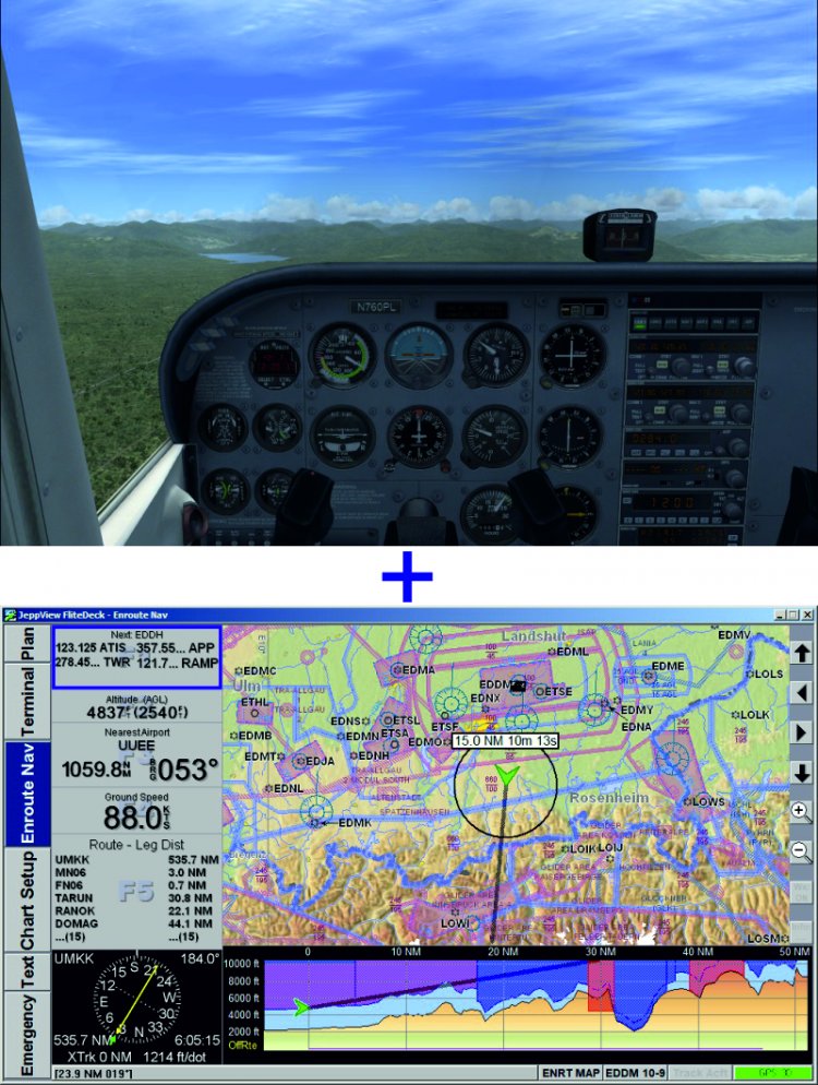
This file is presented step by step instructions on how to connect the Simulator Flight Simulator 2004, Flight Simulator X, X-Plane with FliteDeck and FliteMap. That is the location of your aircraft will be displayed in the navigation software and FliteDeck FliteMap from the company Jeppesen This method does not require the use of WideFS and is suitable for connection to many other navigation programs. I do not know which directory to put the file, but I think he is the right place. PS: I thank all the participants of the forum "A bunch of Msfs and Jeppesen Flitedeck3", information which helped me to lay it all in one statement.
→ Size:
3 MB
→ Date:
15 years ago (13.08.2011 03:26)
→ Author:
Tomflight
→ Approved by moderator:
SLAVJAN
→ License:
Freeware - Free version, Unlimited Distribution
→ Downloaded:
810 time(s)