Flips Просмотр ZIP-архива
flips/readme.txt
Flips version 1.1

Dear Simmers,

I'd like to thank those of you who have helped me to realize that there are at least 3 variations in flightplan formats
all of which can be loaded into FS9 but only one of these could be loaded into the previous Flips version.

Version 1.1 now is capable of reading those 3 variations and I hope it will solve the trouble that you may have had
with reading your flightplans. Especially those flightplans were difficult to load that had been directly edited in FS9.

New in Flips version 1.1:
- added support for 3 variations of FS9.0/FS9.1 flightplan formats (last Flips version: just 1 format)
- added three sample flightplans in dat folder that should work with Flips and that show the variations in supported flightplan formats
- improved help instructions
- improved error messages in case of trouble
- clarified requirements
- added drawing options for the vertical flightplan profile

Flips is a small utility to view FS9 flightplans in Google Earth.
View your entire flightplan in 3D and make sure your chosen waypoints don't let you
miss exiting landmarks along your flight.

Each waypoint of your flightplan is displayed in its proper position by a simplified ICAO symbol representing the
type of NAVAID. The distance from the last fix, total travelled distance and percentage of flightplan completion is
availabe at each waypoint.
A vertical flightplan profile connecting the waypoints is also displayed, but can be switched off
independently in Google Earth. It is possible to include top of climb and descent points in the vertical profile. Simply
specify their desired location along the flightpath as an offset distance off some waypoint.

Flips can convert *.pln files of FS9 formatted flightplans to Google Earth placemark files (*.kml).
Flightplans edited in FS9 and FlightSim Commander can so be displayed. Certainly there will be
a lager number of freeware flightplanners that are also capable of editing FS9 formatted flightplans.


Requirements:
1) Java Runtime Environment JRE 1.4.1 or later (www.sun.com)
    Note: JRE 5.0 and JRE 1.5.0 are just different names for the same JRE
2) Google Earth viewer (earth.google.com)

Install:
Just unzip the archive to any folder of your choice.

Usage:
1) Call flips.bat either by double clicking it or by calling it from a windows cmd prompt.
2) Select a flightplan of yours via 1. Search button or choose one of the sample flightplans from the dat folder.
3) Select a filename for the new placemark file via 2. Search button. You must type in a new filename or choose an
    existing placemark file to overwrite.
 4) Press Save to convert the flightplan into the placemark file.
 5) Exit Flips.
 6) Start Google Earth viewer.
 7) Use File->Open from the main menu to load the placemark file.
 8) The flightplan should now be displayed in Google Earth viewer. Make sure the flightplan displays in the left side bar
     and that the checkbox next to its name is checked. Expand the flightplan in the side bar to see further details.

Also see the small online help or see the image ./dat/help.jpg.

Happy landings,
Michael Rook

[email protected]
55151-flips.zip
| Имя файла | Дата | Размер |
|---|---|---|
| flips/ | 30.10.2014 17:16 | |
| flips/dat/ | 30.10.2014 17:16 | |
| flips/dat/aeronautic.png | 15.09.2005 03:08 | 47 KB |
| flips/dat/EDDR2LFPO.kml | 21.09.2005 06:31 | 5 KB |
| flips/dat/EDDR2LFPO.pln | 26.04.2005 03:36 | 1 KB |
| flips/dat/ESSAESDF10.kml | 21.09.2005 06:31 | 8 KB |
| flips/dat/ESSAESDF10.pln | 20.09.2005 00:49 | 1 KB |
| flips/dat/FS9_Airports.txt | 03.10.2004 19:25 | 4 MB |
| flips/dat/help.jpg | 21.09.2005 05:20 | 161 KB |
| flips/dat/IATA2ICAO.txt | 10.10.2004 17:43 | 53 KB |
| flips/dat/IFR Kingsford Smith Intl to Melbourne Intl.kml | 21.09.2005 06:35 | 5 KB |
| flips/dat/IFR Kingsford Smith Intl to Melbourne Intl.PLN | 19.09.2005 23:40 | 758 B |
| flips/flips.bat | 15.09.2005 03:38 | 58 B |
| flips/flips.gif | 21.09.2005 06:23 | 6 KB |
| flips/flips.jar | 21.09.2005 06:10 | 28 KB |
| flips/flips_large.jpg | 21.09.2005 06:22 | 16 KB |
| flips/placemarks/ | 30.10.2014 17:17 | |
| flips/placemarks/PLCHNTMD.kml | 30.10.2014 17:17 | 3 KB |
| flips/placemarks/YHBAYBUD.kml | 30.10.2014 17:12 | 3 KB |
| flips/readme.txt | 21.09.2005 06:54 | 3 KB |
| avsim_su.diz | 30.10.2014 21:15 | 406 B |
| Итого: | 4 MB | |
Flips
| Rating: 5!
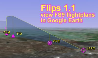
Программка преобразует файл PLN (план полёта) в файл KML, который можно посмотреть в Google Earth. Маршрут и высоту плана полёта. Запускаем файл BAT.... В общем в мануале всё подробно описано.
→ Size:
1 MB
→ Date:
11 years ago (30.10.2014 18:58)
→ Author:
→ Approved by moderator:
SLAVJAN
→ License:
Freeware - Free version, Unlimited Distribution
→ Downloaded:
572 time(s)